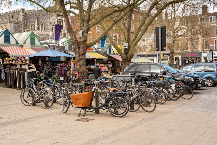
“Are we there yet?” Parents may patiently nod to their children’s insistent nudges on a 20-minute journey to… somewhere. Quite rightly, researchers have asked: twenty minutes to what? The answer may well lie in the question.
At its core, the 20-minute neighbourhood provides practical design principles for placemaking. In a discussion of the perceived benefits and inconveniences of 20-minute neighbourhoods being consulted upon by the Scottish Government under the National Planning Framework (NPF4), Stefano Smith presents the approach as follows in the June 2023 issue of the SPEL journal:
“Local living and 20-minute neighbourhoods are urban planning concepts that aim to create communities where residents can access their daily needs within a 20-minute walk or bicycle ride from their homes”.
Easier said than done. 20-minute neighbourhoods, and their 15-minute siblings, have come under sharp scrutiny and criticism, even as they have been pursued as an opportunity to promote healthy post-lockdown recovery.
Related efforts have encouraged more green infrastructure, among which Natural England’s Green Infrastructure Framework, launched in January 2023. Quite ironically, regeneration, pedestrianisation, and gentrification have been some of the real or imagined woes associated with the intention to provide access to essential amenities and infrastructure to residents, wherever they may live. Reducing the need to travel and improving convenience could be unaffordable and increase traffic congestion. Fears have even been voiced over Big Brother-style surveillance that echo with traumatic memories of Covid-related lockdowns, standing in sharp contrast with the inclusive advocacy undercurrents of walkable neighbourhoods and local quality of life.
Despite the challenges, a survey by YouGov from March 2023 indicates a majority of Britons would be in favour of a 15-minute neighbourhood, citing a shortage in local amenities such as banks and GP surgeries. Challenges also revolve around promoting active mobility in the face of dependence on motorised transport, with related initiatives in Paris having proven contentious for many Parisians despite strong leadership, or the bumpy road that the ambitious Enjoy Waltham Forest programme has had to pedal through to gain traction.
Recent initiatives, such as in Birmingham, begin to reveal tentative recipes to combine the many ingredients that make a place complete in terms of mobility, blue-green infrastructure, food security, diet, public health, care, education, transport, local businesses, finance, well-being, low carbon energy-efficiency and overall resilience. A tall order indeed, and no small feat (all puns intended).
Stepping back, one can see proximity as a timeless set of design principles for complete places. From the city-states of Ancient Greece to the urban village of Montmartre in Paris, the 20-minute neighbourhood has evolved through time(s) and place(s) as a true chameleon. Related concepts have included New Urbanism, urban acupuncture and… placemaking itself.
In many ways, the movement has been a reaction against modernist, blueprint planning that redesigned cities and towns for cars at the relative expense of people and the environment. Precursors to placemaking include William H. Whyte and architect Jan Gehl, or even French thinker Henri Lefebvre who popularised the notion of Right to the City.
In a Swedish context, the design and planning of complete neighbourhoods rests on evidence-based sociotope mapping, which combines expert and resident knowledge about the use of places, as pioneered by Alexander Ståhle and colleagues at the City of Stockholm and planning consultancies.
Rich spatial data is essential to defining and putting 20-neighbourhoods on the map in the most literal sense. In the UK, the former Prince of Wales has also worked to (re)create complete communities and promote high-quality place design for several decades. Countless influences continue to shape the 20-minute neighbourhood principle.
Evidence-based placemaking is also tied to high design quality, architecture, and belonging, as highlighted in Planning for the Future white paper or Planning Policy Wales. Placemaking and design collectives in the UK have included the Place Alliance led by Matthew Carmona. Neighbourhood plans in England and Wales, and place plans in Scotland, have provided ways for communities to be involved in the planning process to help shape places, which may also coincide with establishing complete neighbourhoods.
Benefits also come at a cost and require trade-offs. As Stefano Smith highlights:
“Implementing the 20-minute neighbourhood concept may not be simple, and councils may face several barriers, including differences between urban and rural areas, as well as between new development and existing neighbourhoods.”
Placeholders for transformation
Beyond meeting essential needs, proximity can also enable serendipity and flânerie, where people enjoy places for their own sake. This intangible charm of places partly explains the popularity of touristic cities and towns across the world.
Complete neighbourhoods can also help reduce places’ heavy carbon debt. From strategic policy-making to design codes, town planning can positively shape local quality of life in conjunction with neighbourhood retrofits and health-driven place-based partnerships. As a timeless principle.
Beyond the concept, 20-minute neighbourhoods are like the individuals in John Donne’s 16th Meditation, that postulates that “No man is an island, entire of itself”. Space travels and pervades places via people, goods, infrastructure, and services, where shortages thereof can indicate severe inequalities. The complex interdependencies that underpin inclusive places therefore make it clear that one must also consider the spaces between them to foster collective belonging and resilience.
As a scalable concept, placemaking could help ensure nothing is ever too far for anyone to enjoy as urbanely as possible.
The next post in this series will investigate a handful of 20-minute neighbourhoods as food for practical thought.
For those of us living in, working in and passing through towns and cities, street art has become as familiar as road signage and commercial advertising. Usually taking the form of murals, street art has multiple purposes: it provides artists with a means of displaying their talents and expressing themselves; it can help a place tell a story about itself, highlighting the people and things that have made it what it is today; and it can contribute to the regeneration of a place, demonstrating that communities care about their environment.
Using images from Glasgow – a city with a strong tradition of street art – this photo essay highlights some of the historical, social and artistic elements that have helped to transform parts of the city. It also features extracts from articles and reports that have underlined the importance of street art.
“Artists have embraced the street and the built environment as integral to their work and practice, individual pieces reflecting context and location as surfaces become living canvases, rehumanizing the urban landscape.” – Asli Aktu: Shaping Places Through Art
“In the process of creating and searching for street art pieces, both the artist and the viewer often get to explore parts of the city they would rarely visit otherwise. Places such as alleys or empty lots, dead spaces below or around bridges and other infrastructures, even off-limits terrains such as abandoned tunnels.” – Javier Abarca: From street art to murals: what have we lost?
“According to a research on the effect of mural on personal crime and fear of crime conducted by Md. Sakip, R. et. al. (2016) in Ipoh, Malaysia, most … strongly agree that they are feeling safe when using back alleys with the art mural on a wall. A safe environment is achieved as there are better opportunities for public surveillance caused by the increase in tourists and local community’s awareness. If the environment continues to be safe, the more tourists will be attracted to visit the city.” – Siti Syamimi Oma: Bringing the New to the Old : Urban regeneration through public arts
“Murals are a reflection of the community. They can be historically significant because they serve as a reminder for a particular struggle or victory for the community. They can be beautiful and uplifting, generating a source of pride for residents of a particular neighborhood.” – Summit Learning & C3 Teachers: Does street art make communities better?
“Art can celebrate the qualities that make one place different from another. The best of public art can challenge, delight, educate and illuminate. Most of all, public art creates a sense of civic vitality in the cities, towns and communities we inhabit and visit.” Americans for the Arts: Public Art Network Council Green Paper
“With its ability to embrace multiple urban subcultures and visual styles in a globally distributed practice, street art provides a new dialogic configuration, a post-postmodern hybridity that will continue to generate many new kinds of works and genres.“ – Martin Irvine: The work on the street: street art and visual culture
“Whether sanctioned or unsanctioned, murals are a key component of place-making. They may even have the power to change neighbourhoods.“ – IBI Group: Street murals – the power of public art
Many of the murals included in this blog post are featured in this guide accompanying Glasgow City’s Council’s Mural Trail.
Further reading: more from The Knowledge Exchange on arts and culture
When we last wrote about it in 2019, Mobility-as-a-Service (MaaS) appeared to be on the threshold of transforming the way we get around. An innovative MaaS project had already taken off in Finland, and pilot projects in Sweden and the UK were trialling the advantages of bundling together different transport modes into a single service.
But more recently, some of the high hopes behind MaaS appear to have faded, with some questioning whether the concept needs a reboot.
The benefits of MaaS
The big idea behind MaaS is that anyone can use their mobile device to plan, manage and pay for a journey, selecting from a menu of transport options – such as buses, trains, ride-hailing and bike sharing services.
For passengers, MaaS promises greater freedom of choice. In addition, MaaS has the potential to help support government policy objectives, such as promoting active lifestyles, reducing traffic congestion and improving the air quality of our cities. For transport providers, MaaS could generate new business and cost savings. Research published in 2020 found that transport-related energy consumption can be reduced by up to 25% by allowing travellers unbiased choice of mode of transport for each trip.
Putting the brakes on MaaS
In spite of its appealing possibilities, the momentum driving MaaS seems to have stalled. Reluctance by drivers to give up their cars, the contractual and technical complexity of combining multiple transport modes into one service, and the challenge of getting private companies and public services to work together have all hindered the development of MaaS.
In Finland, once the shining example of MaaS in practice, the operation of the platform has been overshadowed by a conflict over ticketing apps between the country’s leading MaaS provider and Helsinki’s local transport authority. Elsewhere, private sector-led MaaS initiatives have run into financial difficulties.
Debunking the myths about MaaS
Despite these setbacks, MaaS still has its champions. Last month, in a webinar hosted by Intelligent Transport, Sohejl Wanjani and Ulrich Lange from German technology firm Siemens responded to some of the arguments that are often put forward against public transport authorities developing MaaS solutions.
A new platform requires a new app While it’s possible to build a new app solely for MaaS functions, existing apps can be expanded, meaning users don’t have to have multiple accounts and payment methods.
Building a new MaaS project is too big for us Two options are open to providers: start with one service provider, offering a fully integrated service (planning, booking and paying for trips within the MaaS app) and later add additional service providers; alternatively, start with several service providers, and offer only planning and booking, but not payment.
Most users rely on Google Maps. We can’t do better than that The key to a successful MaaS system is data, and transport authorities are rich in data about usage of their services. MaaS systems can use real time data that Google does not have, and can integrate ticketing and booking for all modes of transport. In addition, transport authorities can generate income from their own datasets, adapted to local circumstances. Once passengers are assured of the integrity and quality of the data, they are more likely to use the service.
A good example of this is Denmark’s Rejseplanen. This nationwide mobility platform was launched in 2007, and has since achieved more than 5 million downloads. In Denmark, this app is used more frequently than Google Maps, and its extensive data set continues to drive its popularity. Today, Rejseplanen includes information not only for rail, bus and metro services, but also cycle hire and even domestic air services.
Upgrading to a MaaS platform is not financially viable As cities introduce measures to reduce traffic congestion, it should now be clear that the need to tackle climate change is driving a shift away from private vehicle use to shared modes of transport that are healthier for people and for the planet. MaaS can contribute to climate-friendly travel, while helping transport providers achieve their strategic goals – generating additional revenue streams, increasing passenger usage and creating new mobility services.
Last year, Renfe, the national railway company of Spain, signed a contract with Siemens to develop a nationwide MaaS platform that will allow users to plan, book and pay for trips in a single application. The system will integrate different modes of shared and public transport, such as train, bicycle, metro, bus, car sharing, and scooter services. Renfe clearly sees MaaS as a viable concern; it expects the new service to generate a 4% increase in train travel, 650,000 new customers, and €156m in additional revenue.
MaaS on the move
MaaS is by no means a lost cause. Last month, a research study estimated that the worldwide market for MaaS would grow at a compound annual growth rate (CAGR) of 36.8% over the next five years.
Meanwhile, Berlin’s Jelbi service is currently the world’s largest MaaS solution, bringing together public transport, bike sharing, e-scooter, taxis and ridesharing services, as well as offering 12 “Jelbi Stations” where users can rent, return and recharge a range of different vehicles.
Last year, Pittsburgh’s mayor unveiled its own MaaS programme. Move PGH is a partnership between the city’s public transport authority and an assortment of carpooling, car rental, e-scooter and bike sharing enterprises.
Final thoughts
MaaS is still in its infancy, and it’s too early to be sure of its future direction. While its proponents present a seductive vision of car-free cities, cleaner air, clearer streets and almost unlimited choices for passengers, the reality may be very different.
A 2020 study questioned the assumptions surrounding MaaS, and argued that, while MaaS has strong potential for increased mobility, there are also “…unanticipated societal implications that could arise from a wholesale adoption of MaaS in relation to key issues such as wellbeing, emissions and social inclusion.”
With MaaS at a crossroads, it will be worth revisiting this issue to assess its progress.
Further reading: more on travel and transport from The Knowledge Exchange blog
Idox’s transport solutions support traffic management and the delivery of real-time passenger information across all modes of transport. Through the use of new digital technology, we help traffic managers and local transport authorities to harness data and inform the design of smart transport systems that ease congestion on existing networks. Further information here
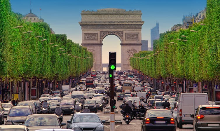
A stretch of the Champs-Élysées around the Arc de Triomphe in Paris is due to be pedestrianised by 2030. Shutterstock
Answer: the vehicles on our streets, primarily the not-so-humble passenger car.
Despite the (slow) migration to electric-powered cars, consumer trends are making driving even more wasteful and unequal. A recent analysis found the emissions saved from electric cars have been more than cancelled out by the increase in gas-guzzling Sport Utility Vehicles (SUVs). Around the world, SUVs alone emit more carbon pollution than Canada or Germany, and are causing a bigger increase in climate pollution than heavy industry.
While cars are sometimes necessary for people’s mobility and social inclusion needs – not least those with disabilities – car-centric cities particularly disadvantage the already-marginalised. In the UK, women, young and older people, those from minority communities and disabled people are concentrated in the lowest-income households, of which 40% do not have a car. In contrast, nearly 90% of the highest-income households own at least one car.
So the driving habits of a minority impose high costs on society, and this is especially true in cities. Copenhagen, for example, has calculated that whereas each kilometre cycled benefits society to the tune of €0.64 (53 pence), each kilometre driven incurs a net loss of -€0.71 (-59p), when impacts on individual wellbeing (physical and mental health, accidents, traffic) and the environment (climate, air and noise pollution) are accounted for. So each kilometre travelled where a car is replaced by a bicycle generates €1.35 (£1.12) of social benefits – of which only a few cents would be saved by switching from a fossil-fuelled to an electric-powered car, according to this analysis.
Reducing car use in cities
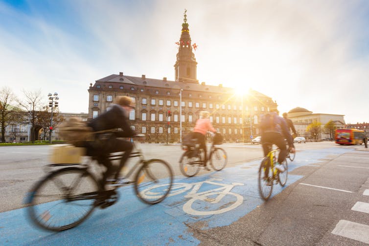
Half a century ago, the Danish capital was dominated by cars. But following grassroots campaigns to change policies and streets, including replacing car parking with safe, separated bike lanes, Copenhagen has increased its biking share of all trips from 10% in 1970 to 35% today. In 2016, for the first time, more bicycles than cars made journeys around the city over the course of that year.
Bicycles rule the centre of Copenhagen following campaigns to replace parking with safe bike lanes. Shutterstock
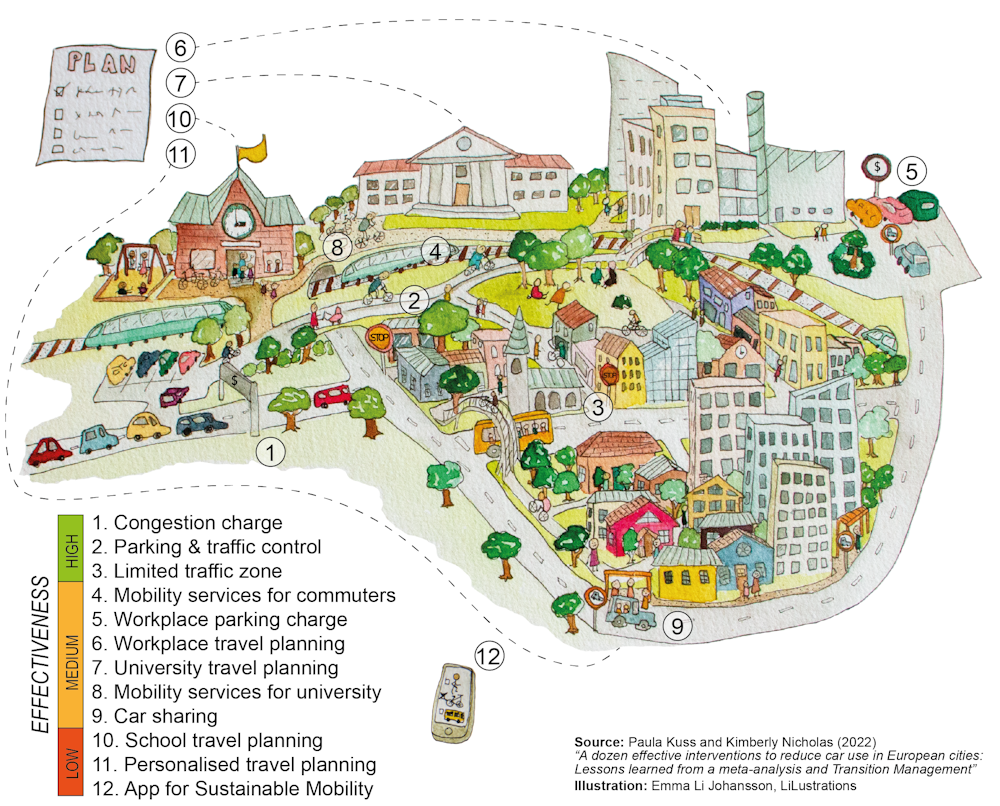
But while many other car-limiting initiatives have been attempted around the world, city officials, planners and citizens still do not have a clear, evidence-based way to reduce car use in cities. Our latest research, carried out with Paula Kuss at the Lund University Centre for Sustainability Studies and published in Case Studies on Transport Policy, seeks to address this by quantifying the effectiveness of different initiatives to reduce urban car use.
Our study ranks the 12 most effective measures that European cities have introduced in recent decades, based on real-world data on innovations ranging from the “carrot” of bike and walk-to-work schemes to the “stick” of removing free parking. The ranking reflects cities’ successes not only in terms of measurable reductions in car use, but in achieving improved quality of life and sustainable mobility for their residents.
In all, we have screened nearly 800 peer-reviewed reports and case studies from throughout Europe, published since 2010, seeking those that quantified where and how cities had successfully reduced car use. The most effective measures, according to our review, are introducing a congestion charge, which reduces urban car levels by anywhere from 12% to 33%, and creating car-free streets and separated bike lanes, which has been found to lower car use in city centres by up to 20%. Our full ranking of the top 12 car-reducing measures is summarised in this table: https://datawrapper.dwcdn.net/NDMp4/12/
The inequality of car use
Cars are inherently inefficient and inequitable in their use of land and resources. On average, they spend 96% of their time parked, taking up valuable urban space that could be put to more beneficial uses such as housing and public parks. In Berlin, car users on average take up 3.5 times more public space than non-car users, primarily through on-street parking.
And it is overwhelmingly richer people who drive the most: in Europe, the top 1% by income drive nearly four times more than the median driver, accounting for some 21% of their personal climate footprint. For these highest emitters, climate pollution from driving is second only to flying (which, on average, generates twice as many emissions).
Prioritising cars as a means of transport also favours suburban sprawl. City suburbs typically possess larger homes that generate higher levels of consumption and energy use. North American suburban households consistently have higher carbon footprints than urban ones: one study in Toronto found suburban footprints were twice as high.
It’s also clear that road traffic levels swell to fill the size of the roads built – yet traffic planning routinely ignores the fact that this “induced demand” exaggerates the benefits and underestimates the costs of building more roads.
Electric vehicles are necessary, but they’re not a panacea. Since cars tend to be on the road for a long time, the migration to electric vehicles is very slow. Some studies anticipate relatively small emissions reductions over the coming decade as a result of electric vehicle uptake. And even if there’s nothing damaging released from an electric car’s exhaust pipe, the wear of car brakes and tyres still creates toxic dust and microplastic pollution. However a car is powered, can it ever be an efficient use of resources and space to spend up to 95% of that energy moving the weight of the vehicle itself, rather than its passengers and goods?
COVID-19: a missed opportunity?
Our study assesses urban mobility innovations and experiments introduced before the pandemic was declared. In response to COVID-19, travel habits (to begin with, at least) changed dramatically. But following large reductions in driving during the spring of 2020, road use and the associated levels of climate pollution have since rebounded to near pre-pandemic levels. Indeed, in Sweden, while public transport use declined by around 42% during the first year of the pandemic, car travel declined by only 7% in the same period, leading to an overall increase in the proportion of car use.
Commuter traffic in Stockholm in November 2021. Sweden has seen an overall increase in its proportion of car use during the pandemic. Shutterstock
While entrenched habits such as car commuting are hard to shift, times of disruption can offer an effective moment to change mobility behaviour – in part because people forced to try a new habit may discover it has unexpected advantages. For such behaviour to stick, however, also requires changes in the physical infrastructure of cities. Unfortunately, while European cities that added pop-up bike lanes during the pandemic increased cycling rates by a stunning 11-48%, we are now seeing a return to car-centric cities, with extra car lanes and parking spaces once again displacing cycle lanes and space for pedestrians.
Overall, the opportunities to align pandemic recovery measures with climate targets have largely been squandered. Less than 20% of government spending on pandemic measures globally were likely to also reduce greenhouse gas emissions.
The extent to which workers resume driving to their offices is another key issue determining future car use in cities. Thoughtful travel policies to reduce unnecessary travel, and opportunities for faraway participants to fully participate in meetings and conferences digitally, could slash emissions by up to 94% – and save time to boot. Those who work remotely three or more days per week travel less overall than their peers. But long car commutes can quickly wipe out such emissions savings, so living close to work is still the best option.
No silver bullet solution
The research is clear: to improve health outcomes, meet climate targets and create more liveable cities, reducing car use should be an urgent priority. Yet many governments in the US and Europe continue to heavily subsidise driving through a combination of incentives such as subsidies for fossil fuel production, tax allowances for commuting by car, and incentives for company cars that promote driving over other means of transport. Essentially, such measures pay polluters while imposing the social costs on wider society.
City leaders have a wider range of policy instruments at their disposal than some might realise – from economic instruments such as charges and subsidies, to behavioural ones like providing feedback comparing individuals’ travel decisions with their peers’. Our study found that more than 75% of the urban innovations that have successfully reduced car use were led by a local city government – and in particular, those that have proved most effective, such as congestion charges, parking and traffic controls, and limited traffic zones.
But an important insight from our study is that narrow policies don’t seem to be as effective – there is no “silver bullet” solution. The most successful cities typically combine a few different policy instruments, including both carrots that encourage more sustainable travel choices, and sticks that charge for, or restrict, driving and parking.
So here are the 12 best ways to reduce city car use:
1. Congestion charges
The most effective measure identified by our research entails drivers paying to enter the city centre, with the revenues generated going towards alternative means of sustainable transport. London, an early pioneer of this strategy, has reduced city centre traffic by a whopping 33% since the charge’s introduction by the city’s first elected mayor, Ken Livingstone, in February 2003. The fixed-charge fee (with exemptions for certain groups and vehicles) has been raised over time, from an initial £5 per day up to £15 since June 2020. Importantly, 80% of the revenues raised are used for public transport investments.
Other European cities have followed suit, adopting similar schemes after referenda in Milan, Stockholm and Gothenburg – with the Swedish cities varying their pricing by day and time. But despite congestion charges clearly leading to a significant and sustained reduction of car use and traffic volume, they cannot by themselves entirely eliminate the problem of congestion, which persists while the incentives and infrastructure favouring car use remain.
2. Parking and traffic controls
In a number of European cities, regulations to remove parking spaces and alter traffic routes – in many cases, replacing the space formerly dedicated to cars with car-free streets, bike lanes and walkways – has proved highly successful. For example, Oslo’s replacement of parking spaces with walkable car-free streets and bike lanes was found to have reduced car usage in the centre of the Norwegian capital by up to 19%.
3. Limited traffic zones
Rome, traditionally one of Europe’s most congested cities, has shifted the balance towards greater use of public transport by restricting car entry to its centre at certain times of day to residents only, plus those who pay an annual fee. This policy has reduced car traffic in the Italian capital by 20% during the restricted hours, and 10% even during unrestricted hours when all cars can visit the centre. The violation fines are used to finance Rome’s public transport system.
4. Mobility services for commuters
The most effective carrot-only measure identified by our review is a campaign to provide mobility services for commuters in the Dutch city of Utrecht. Local government and private companies collaborated to provide free public transport passes to employees, combined with a private shuttle bus to connect transit stops with workplaces. This programme, promoted through a marketing and communication plan, was found to have achieved a 37% reduction in the share of commuters travelling into the city centre by car.
5. Workplace parking charges
Another effective means of reducing the number of car commuters is to introduce workplace parking charges. For example, a large medical centre in the Dutch port city of Rotterdam achieved a 20-25% reduction in employee car commutes through a scheme that charged employees to park outside their offices, while also offering them the chance to “cash out” their parking spaces and use public transport instead. This scheme was found to be around three times more effective than a more extensive programme in the UK city of Nottingham, which applied a workplace parking charge to all major city employers possessing more than ten parking spaces. The revenue raised went towards supporting the Midlands city’s public transport network, including expansion of a tram line.
Norwich reduced car commuters by nearly 20% with its workplace travel plan, including swapping car for bike parking. Shutterstock
6. Workplace travel planning
Programmes providing company-wide travel strategies and advice to encourage employees to end their car commutes have been widely used in cities across Europe. A major study, published in 2010, assessing 20 cities across the UK found an average of 18% of commuters switched from car to another mode after a full range of measures were combined – including company shuttle buses, discounts for public transport and improved bike infrastructure – as well as reduced parking provision. In a different programme, Norwich achieved near-identical rates by adopting a comprehensive plan but without the discounts for public transport. These carrot-and-stick efforts appear to have been more effective than Brighton & Hove’s carrot-only approach of providing plans and infrastructure such as workplace bicycle storage, which saw a 3% shift away from car use.
7. University travel planning
Similarly, university travel programmes often combine the carrot of promotion of public transport and active travel with the stick of parking management on campus. The most successful example highlighted in our review was achieved by the University of Bristol, which reduced car use among its staff by 27% while providing them with improved bike infrastructure and public transport discounts. A more ambitious programme in the Spanish city of San Sebastián targeted both staff and students at Universidad del País Vasco. Although it achieved a more modest reduction rate of 7.2%, the absolute reduction in car use was still substantial from the entire population of university commuters.
8. Mobility services for universities
The Sicilian city of Catania used a carrot-only approach for its students. By offering them a free public transport pass and providing shuttle connections to campus, the city was found to have achieved a 24% decrease in the share of students commuting by car.
Catania achieved a 24% decrease in the share of students commuting by car. Shutterstock
9. Car sharing
Perhaps surprisingly, car sharing turns out to be a somewhat divisive measure for reducing car use in cities, according to our analysis. Such schemes, where members can easily rent a nearby vehicle for a few hours, have showed promising results in Bremen, Germany and Genoa, Italy, with each shared car replacing between 12 and 15 private vehicles, on average. Their approach included increasing the number of shared cars and stations, and integrating them with residential areas, public transport and bike infrastructure.
Both schemes also provided car sharing for employees and ran awareness-raising campaigns. But other studies point to a risk that car sharing may, in fact, induce previously car-free residents to increase their car use. We therefore recommend more research into how to design car sharing programmes that truly reduce overall car use.
10. School travel planning
Two English cities, Brighton & Hove and Norwich, have used (and assessed) the carrot-only measure of school travel planning: providing trip advice, planning and even events for students and parents to encourage them to walk, bike or carpool to school, along with providing improved bike infrastructure in their cities. Norwich found it was able to reduce the share of car use for school trips by 10.9%, using this approach, while Brighton’s analysis found the impact was about half that much.
11. Personalised travel plans
Many cities have experimented with personal travel analysis and plans for individual residents, including Marseille in France, Munich in Germany, Maastricht in the Netherlands and San Sebastián in Spain. These programmes – providing journey advice and planning for city residents to walk, bike or use (sometimes discounted) public transport – are found to have achieved modest-sounding reductions of 6-12%. However, since they encompass all residents of a city, as opposed to smaller populations of, say, commuters to school or the workplace, these approaches can still play a valuable role in reducing car use overall. (San Sebastián introduced both university and personalised travel planning in parallel, which is likely to have reduced car use further than either in isolation.)
12. Apps for sustainable mobility
Mobile phone technology has a growing role in strategies to reduce car use. The Italian city of Bologna, for example, developed an app for people and teams of employees from participating companies to track their mobility. Participants competed to gain points for walking, biking and using public transport, with local businesses offering these app users rewards for achieving points goals.
There is great interest in such gamification of sustainable mobility – and at first glance, the data from the Bologna app looks striking. An impressive 73% of users reported using their car “less”. But unlike other studies which measure the number or distance of car trips, it is not possible to calculate the reduction of distance travelled or emissions from this data, so the overall effectiveness is unclear. For example, skipping one short car trip and skipping a year of long driving commutes both count as driving “less”.
While mobility data from apps can offer valuable tools for improved transport planning and services, good design is needed to ensure that “smart” solutions actually decrease emissions and promote sustainable transport, because the current evidence is mixed. For instance, a 2021 study found that after a ride-hailing service such as Uber or Lyft enters an urban market, vehicle ownership increases – particularly in already car-dependent cities – and public transport use declines in high-income areas.
Cities need to re-imagine themselves
Reducing car dependency is not just a nice idea. It is essential for the survival of people and places around the world, which the recent IPCC report on climate impacts makes clear hinges on how close to 1.5°C the world can limit global warming. Avoiding irreversible harm and meeting their Paris Agreement obligations requires industrialised nations such as the UK and Sweden to reduce their emissions by 10-12% per year – about 1% every month.
Yet until the pandemic struck, transport emissions in Europe were steadily increasing. Indeed, current policies are predicted to deliver transport emissions in 2040 that are almost unchanged from 50 years earlier.
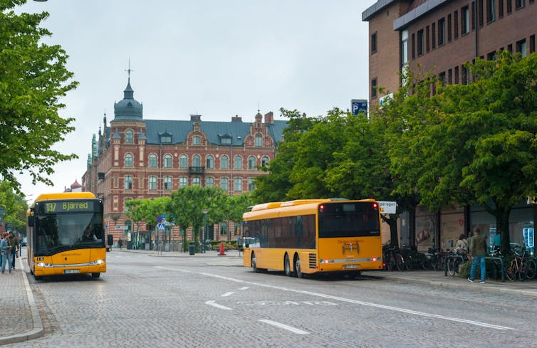
Local buses in the Swedish city of Lund, home of the Centre for Sustainability Studies. Shutterstock
To meet the planet’s health and climate goals, city governments need to make the necessary transitions for sustainable mobility by, first, avoiding the need for mobility (see Paris’s 15-minute city); second, shifting remaining mobility needs from cars to active and public transport wherever possible; and finally, improving the cars that remain to be zero-emission.
This transition must be fast and fair: city leaders and civil society need to engage citizens to build political legitimacy and momentum for these changes. Without widespread public buy-in to reduce cars, the EU’s commitment to deliver 100 climate-neutral cities in Europe by 2030 looks a remote prospect.
Radically reducing cars will make cities better places to live – and it can be done. A 2020 study demonstrated that we can provide decent living standards for the planet’s projected 10 billion people using 60% less energy than today. But to do so, wealthy countries need to build three times as much public transport infrastructure as they currently possess, and each person should limit their annual travel to between 5,000 kilometres (in dense cities) and 15,000 kilometres (in more remote areas).
The positive impact from reducing cars in cities will be felt by all who live and work in them, in the form of more convivial spaces. As a journalist visiting the newly car-free Belgian city of Ghent put it in 2020:
The air tastes better … People turn their streets into sitting rooms and extra gardens.
Cities need to re-imagine themselves by remaking what is possible to match what is necessary. At the heart of this, guided by better evidence of what works, they must do more to break free from cars.
Midtown Tampa is the kind of instant city that 20 years ago I would’ve raved about. It’s another great example of The Urban Experiment.
This is a mixed-use, walkable development that has been created out of whole cloth west of downtown, near the airport. It’s a sort of second generation version of these types of projects, and measurably better than the first generation.
Before I describe it further, though, it’s interesting to trace a brief history of apartment communities in the US.
Not long ago, not far away
In America, renting an apartment has been a choice of a minority of households since the New Deal incentivized home ownership. About 1/3 of households today are renters, though early in the twentieth century it was close to 2/3. I won’t comment on if that was good or bad policy. It’s just to note the context, note the incentives and how we’ve changed.
Apartments were most commonly rented in small buildings in that previous era. They were the Missing Middle types so often discussed, and highlighted very well by Dan Parolek of Opticos Design. Yes, there were larger buildings as well, and a wide variety of SROs, apartment hotels and boarding houses. But most of what housed people were ancillary apartments, duplexes, triple-deckers, fourplexes, etc etc. This was very common for middle-class people, virtually all over America.
As we became wealthy, single family ownership became all the rage, egged on by financing incentives and regulatory changes (zoning). At the same time, larger capital flows became more dominant in real estate, and the nature of apartment living began to change. Apartments increasingly were built in larger “complexes” of 100 or 200 units all at one time in one location. In order to make apartment living an attractive alternative to home ownership, and not just for the poor or those without choices, developers began adding “amenities” such as pools and common green spaces. Those were the sorts of things not even contemplated in the “Missing Middle” era. Back then, an apartment was just a place to live in a neighbourhood, no different than the house next door or around the corner. The “amenities” were often in public parks.
As time went on, the arms race for amenities ramped up. Soon were added fitness centres, spas, covered parking, valet services and more. Newer apartment complexes today are often touted as “luxury apartments.” In addition to the amenities, they also tout granite counter-tops, stainless steel appliances and whirlpool tubs in the units. Going after the renter by choice market has necessitated this push to go ever more upscale and out-class the competition. That’s not surprising, it’s just a certain element of markets and competition at work.
The walkability factor
Now enter the 2000s, and the slow but noticeably growing interest in urban living. In some cities, the newly thriving commercial districts, walkable to many apartments, became a new, sexy amenity. Many smaller developers smartly capitalized on this with renovations of historic buildings, loft conversions and some new urban infill. They helped create an urban market that had some of the new amenities renters (and some home owners) were looking for. Their buildings didn’t have pools or covered parking, but they had cool bars and restaurants to walk to, art galleries, lively streets and more things that appeal to a certain part of the population.
The folks who deploy big investment capital naturally noticed this change. And they didn’t want to miss out on the trend. For over a decade, every healthy market has seen an influx of large “luxury apartment” buildings of about 200 units in urban areas, complete with all the amenities they’re used to providing in suburban locations. You guessed it – the pool, the fitness center, covered parking, etc etc.
Again, I’m not passing judgment. This is simply an example of how development happens in modern America. In many cases, these larger entities deploy tens of millions of dollars to buy and upgrade buildings, build new ones and create portfolios of hundreds and hundreds of apartments. It’s very smart business. Some of the end results can be excellent, some very mediocre, but nearly all have been well received in the marketplace. Urbanist snobs like me might ask questions, but clearly the people renting the apartments are responding positively.
Enter Midtown Tampa
Midtown Tampa is simply another in the latest version of this phenomenon. It’s a brand new place, by different accounts, either 12 or 30 years in the making.
The apartments are very well appointed, the amenities are first-class. It also includes fantastic eating and drinking options, some retail, a Whole Foods and new office space. It truly is an “instant city” in the sense it has so much of what someone might need as part of a daily or weekly routine in one compact location. Despite the Florida heat, you can walk from your apartment indoors to the gym, where you can work out in perfect air conditioned comfort. This is the new, 21st century apartment complex.
Midtown has the trendiest new bar in town, and it looks like the kind of place I’d enjoy spending too much time in. It has a “signature scent.” Yes, that’s actually a thing. It’s not a cheap place at all, and not intended to be. The rents are about $3 per square foot. That’s the top of the market in Tampa, and in many similar markets in the US. You can do the math on what a simple, 900 square foot two bedroom apartment costs.
Everything in this development is impeccably managed. They do everything well that our cities do poorly. Trash and cleanliness, security, parking, and public space management are all incredibly well thought-through and executed. It gives people who advocate for privatization of city governance great ammunition.
So again, I’m not saying this is BAD. I think there’s much to admire and like. It’s just that this is another example of how we only produce this kind of development now. It’s either large single-family subdivisions on the edge of the city, or mega-investment “instant cities.” There’s nothing in between. It’s not just that the Missing Middle buildings are often zoned out of existence, it’s that the entire ecosystem of finance, acquisition, construction and more seems to make it virtually impossible to do again.
There’s no space in our system for the kind of change that gave us Chicago, or even my city. The professionalization of everything has created this predicament where the entire system pushes for bigger and more complicated projects and efforts of all kinds. This is not a “find a magic policy” problem. It’s the direct result of decades of policy, all made with good intentions and responding to constituents, but quietly damaging our systems piece by piece.
This isn’t healthy for our cities, and it’s especially not healthy for a democratic society. In this system, there seems to be little opportunity for people to build for themselves, to build wealth for themselves, and create the kinds of “messy” places that urbanists like myself most admire. The only option is to do it “sub-rosa” as Johnny Sanphillipo would say. And he’s right. That’s exactly what happens in the real world, often outside the view of the local authorities.
I have no objection to Midtown Tampa at all. In fact, it’s quite well done in many ways. But this simply cannot be the only solution to the development of our cities. We’ve got to unleash the swarm, as I like to say, or else all the current problems we fret about will only get worse.
Kevin Klinkenberg has worked as an urban designer, architect and planner. His blog – The Messy City – looks at ways to use urban design and development to make people’s lives healthier, wealthier and happier.
Further reading: more from The Knowledge Exchange blog on urban development
People in cities often choose how to travel based on how long it will take. In recent years, navigation apps such as Google Maps and CityMapper have enabled people to decide between various modes of transport by seeing which one most quickly gets them where they want to go.
Cities of course have long dedicated a disproportionate amount of space to cars. Although in some parts of the global north – and in certain demographics – car use is declining, elsewhere it has, unsurprisingly, increased.
In a recent study, we modelled what would happen to average travelling times in a city if people were given only one other option – using the car or using another mode of transport – and if they acted only in their own interest (getting to their destination as fast as possible).
We wanted to see what would happen if everyone acted selfishly. How would that compare, we wondered, with a theoretical case in which people chose their mode to minimise travel times for society as a whole and not only for themselves.
City spaces
Using mathematical modelling, we found that if all travellers behave selfishly, and if we have a system that not only makes it relatively inexpensive to use a car, but also allows congestion to affect non-car users (cyclists, public transport users, pedestrians etc), collectively we all end up taking longer to get where we need to go – whether we’re driving a car or not.
City streets are often designed to make travelling by car faster and more efficient. And despite there being, for instance, an increasing amount of cycling infrastructure worldwide and higher satisfaction among people who commute by bike, it is still very common to see narrow, disconnected cycling lanes which result in congestion induced by private cars affecting cycling travel times too.
Mixed-use lanes – those that are used by both private cars and public buses, as opposed to dedicated bus lanes – have the same effect: car congestion affects bus users too. Without proper infrastructure, there are therefore no incentives to use public transport or active transport options, such as cycling and walking.
And even when there is a cycling path network or dedicated bus lanes, if these cross over or otherwise intermittently share space with the general road system, this also slows everybody down. It makes the system as a whole less efficient.
Similarly, free parking for private vehicles also results in longer travelling times for everyone – including non-car users – because they negate the benefits, for individuals, of not using a car if others still do.
We found that selfish behaviour with such inadequate infrastructure results naturally in more cars, more congestion, and longer travel times. If using a car remains the easier and quicker option (on an individual level), people will keep using cars and cities will remain congested. By trying individually to win, we all lose.
Competing priorities
One alternative is to design more collaborative transport networks in which we all accept some personal delay to achieve a distribution that is better for society. We could, for example, include not only personal cost in some of the apps we use, but societal costs also. What if Google Maps told you not only where congestion is in real-time and what would be the quickest transport mode to choose for you as an individual, but which transport mode would offer the best results for your neighbourhood, your family, your colleagues, or your city?
Research has shown how difficult it is, however, to shift commuter behaviour. It also highlights the public opposition there has been to alternative measures such as limiting maximum speeds in order to lower traffic injuries, despite such measures saving lives.
Given this, it could prove difficult to convince some car users to sacrifice personal efficiency for the greater good. But we could start by at least making these trade-offs explicit.
Motorised private transport has a wide variety of impacts that threaten a city’s sustainability, not least the wellbeing and health of its citizens. It contributes to air pollution and climate change through vehicle emissions and results in traffic injuries and nurtures sedentary lifestyles.
To encourage people to use more sustainable alternatives to car transport, cities need strong policies that steer people away from using their cars. So far, these have included low-traffic neighbourhoods and congestion charges that try to make car drivers pay for the congestion they are causing.
Elsewhere, systems have been implemented that attract people to transport modes, such as safe lanes for cycling, that typically have better environmental and social outcomes. These systems emphasise individualistic attitudes but target societal costs to those most responsible for them.
Ideally, we should create policies that help us act in the interest of our community. In the meantime, policies that push people away from their private cars could bring us closer to what would be optimal for the collective – even if we are all acting in our own interests.
As 2021 draws to an end, much of the world is slowly emerging towards post-pandemic life. Focus is shifting from response to recovery. Governments, activists and academics are arguing for a green recovery – a one-off opportunity to truly incorporate climate change objectives, sustainability and equity into future development.
Cities served as the frontline to the pandemic and will continue to do so in efforts to transition towards a sustainable recovery. Building the cities of the future was the focus of a recent NESTA webinar in conversation with Daisy Narayanan, Senior Manager of Placemaking and Mobility at the City of Edinburgh Council. It highlighted the importance of creating urban environments that put people first for healthy, safe and sustainable communities.
Opportunities for cities
Narayanan argued that positives can be taken from COVID-19, as it inspired collaboration across sectors and communities whilst proving the responsiveness and adaptability of traditional systems. She believes that this mindset should be harnessed going forward to facilitate meaningful changes and progression within our cities for everyone.
Describing herself as a ‘relentless optimist’, she stated, “I think there is something about this moment in time where there is a real kind of desire to move forward, in a way that changes how things used to be, into what things need to be or should be. I think there is a lot of excitement around shaping that together.”
Narayanan went on to talk about the opportunities she sees for transforming our public spaces with collaboration across planning, transport and economic development. She is excited by the potential of concepts such as the ‘20-minute neighbourhood’ and its growing presence within city planning around the world and in her own city of Edinburgh.
More broadly, she is excited that citizens are recognising the importance of living well locally and that community wellbeing should be inherent to placemaking.
The inequality of green space
Whilst positives can be drawn from collaboration during the pandemic, it also magnified how divisive our cities’ environmental issues can be. Pollution, congestion and dwindling green spaces compounded the health and social challenges for many of those living in urban areas.
With most inside amenities forced to close during periods of lockdown, city dwellers turned to parks for exercise and socialising in unprecedented numbers. However, urban green spaces proved to be unequal in distribution. Socioeconomic status is the most likely determinant to green space accessibility and quality, and access is typically limited to the more scenic neighbourhoods with higher average incomes.
The benefits of urban green spaces to an individual’s health and wellbeing are well documented, with associations between the presence of green spaces, greater quality of life and decreased risk of excess mortality. There is growing research suggesting that city populations without the provision of green spaces in the UK had typically higher instances of mental health issues, such as COVID-related anxiety and isolation.
Of course, the provision of green spaces is only one of a number of factors highlighted in discussions around equalities, health and well-being in urban areas. However, the pandemic exposed the barriers to accessing the potential value provided by such spaces which could continue to reinforce inequalities.
Can a green integrated approach to transforming our cities tackle inequality and promote wellness in the post-COVID city?
Lessons from Milan’s green placemaking
During the webinar, Narayanan briefly touched upon how Milan is a commendable example of a city making really big changes to its public spaces for the benefit of its citizens.
The city has impressive commitments for using nature-based solutions to increase resilience towards future environmental and health crises, whilst stimulating an equity-based approach to tackling climate change.
The Mayor of Milan, Giuseppe Sala, committed his city to green urbanism before the pandemic and has since campaigned for efforts to be increased due to the unequal challenges created in cities.
He stated, “The green and just recovery that is needed to create more sustainable and healthier cities sees urban nature as a key element for building back better… I have been clear that any recovery in my city, in Italy and for Europe, must be rooted in these principles of equity and climate action.”
Sala aims to plant three million trees across Milan by 2030 to tackle climate change and to halt the trend of deteriorating air quality. At the core of this strategy is the transformation of derelict land in deprived neighbourhoods into 20 high quality urban parks.
The city government is providing for residents to have trees planted in their private gardens and upon flat rooftops, whilst greenery is being incorporated into car parks and on the sides of office blocks.
Integrating green spaces, food supply and equity, the city’s growing number of community gardens and allotments are often situated upon apartment block rooftops. Residents can grow and collect food whilst local restaurants are encouraged to use ingredients from the nearby streets. Locals have also lauded the social spaces that these gardens have become, as users can collaborate and educate each other through gardening.
Perhaps the most symbolic project in Milan’s transition is the Bosco Verticale or ‘Vertical Forest’- two residential apartment blocks which have been almost completely covered with trees, perennials and shrubbery. Designed by architect Stefano Boeri, the 80m and 112m high buildings have the equivalent vegetation of 30,000 square metres worth of woodland upon only 3,000 square metres of concrete.
Consisting of hundreds of plant species of various shapes and colours, the project is a popular, living landmark throughout the year. Not only an appealing addition to the Milan skyline, the urban vegetation has been a remarkable success – lowering temperatures, encouraging 20 new bird species into the area and absorbing 30 metric tonnes of carbon dioxide from the atmosphere each year.
The towers demonstrate the multiple benefits that can be achieved from small-scale integrated approaches to increasing green spaces. The concept is already being replicated in cities around the world.
If successful, it is believed that Milan’s vast increase in vegetation has the potential to absorb an additional five million tonnes of carbon dioxide each year, whilst significantly decreasing the presence of pollutant particles in the air associated with cancer and respiratory diseases.
Concluding thoughts
Milan’s transformation is exemplary of a city that is learning from previous vulnerabilities, using urban space to directly promote citizen wellbeing whilst tackling climate change.
As Narayanan argues, all cities now have the opportunity to put people’s needs and wellbeing at the centre of future urban spaces. Whilst citizens and authorities often both want to achieve attractive, sustainable and healthy places, she argues that citizen voices get lost in consultation.
As a step to progressing away from this, she says: “Consultations should be more like conversations. Discussions need to be done respectfully, evidence-based, data-based and using people’s stories and life as the basis for change.”
More from The Knowledge Exchange blog on placemaking and liveable cities:
The concept of a 15-minute city, where everything you need for daily life is within a quarter of an hour walk of your front door, was already giving city planners something to think about before COVID-19 . But as neighbourhoods, and the people living in them, grappled with multiple lockdowns throughout 2020, the idea really gained traction.
Nowhere more so than in Paris, where the mayor, Anne Hidalgo, made it the centrepiece of her successful 2020 re-election campaign. Hidalgo’s aim was to create self-sufficient communities throughout the city, where everything is a short walk or bike ride away.
In Sweden, they are tightening the time frame even further. A one-minute city pilot called Street Moves aims to “reclaim the streets” from cars by creating numerous pop-up public amenities, with the overall intention of giving the public a say in what’s on their doorstep.
It is hoped the government-backed initiative will be picked up by municipalities across the whole country, but can such a hyper-local proposition really work on a national scale?
For Street Moves project manager, Daniel Byström, who works for ArkDes – the architecture and design think-tank leading the project – the pilot is trying to inspire new ways of approaching urban development rather than attempting to offer instant wholesale change.
“The ambition is to get a spread [of streets across Sweden], with different municipalities being able to make their own intervention,” says Byström. “However, I think many of the municipalities in Sweden are not ready to do it themselves, so for me the central part of the project is not the physical outcome by itself, but more to showcase an approach for how we can work with urban planning, urban development and street development.”
Image: StreetMoves / Daniel Byström
Under the plans, a kit of modular wooden street furniture has been designed, which can be slotted into an area the size of a car parking space. These kits have been designed to be flexible depending on the needs of the area – an important point in terms of scaling up the initiative, since it’s not claiming to be a one-size-fits-all solution. Rather it aims to add genuine value to an area.
Five streets have been piloted since the project’s launch last September, including three in Stockholm and one in both Helsingborg and Gothenburg, with more on the way.
So far, they have created new bench space, picnic tables, planters and e-scooter parking but Byström says this is just the beginning. “In the next step, we will look for more sophisticated solutions [based] around smart cities, such as infrastructure for charging electric cars and scooters.”
He says the one-minute city initiative – which has been funded by Vinnova, the Swedish government’s innovation agency – is also about giving the public more ownership over their streets, with residents being involved early on in the design process.
This resident involvement is getting positive results so far, with ArkDes claiming that 70% people surveyed about the Stockholm projects were positive. They also saw a 400% increase in the movement of people on the streets around each unit.
When coupled with the aftermath of COVID-19, this offers an exciting proposition to “reactivate” Sweden’s streets and make cities more resilient and adaptable to change, Byström adds.
“One of the things that you can see, for example, with growing digitalisation and people working from everywhere, is open-air shared office space, so it could be anything and that is the beauty of this initiative.”
The flexibility of the scheme could prove crucial when considering if this could be scaled up on a national level. Cities across Sweden will be looking for ways to bounce back in new and innovative ways after the pandemic and this could play an important role in that process. One-minute cities could also prove to be a crucial pillar in the success of Sweden’s goal for 2030 that “every street in Sweden is healthy, sustainable and vibrant.”
Our thanks to RICS for permission to republish this article which first appeared in Modus in July 2021.
Further reading: more from The Knowledge Exchange blog on urban areas
What kinds of cities do we want to live in? It’s a question that has taken on increased urgency in the past year. But even before the global pandemic, there was growing concern about how to address the challenges facing the world’s cities, especially the threat of climate change.
Tackling traffic congestion, reducing air pollution, improving sustainable mobility and ensuring easy access to green space and essential services are all significant factors that can advance the quality of life in our urban areas. The lockdowns and other restrictions imposed by governments to contain the spread of the coronavirus (COVID-19) have thrown these issues into sharper focus.
An alternative vision
There is now a growing consensus that a new road map is needed for the development of liveable cities. This means changing lifestyles so that sociability, sustainability and wellbeing are prioritised – in short, the common good should drive decisions about urban planning.
One of the ideas for promoting this approach is the 15 minute neighbourhood, in which home, education, work, healthcare and other essential services are all within a 15 minute reach by walking or cycling. This is the vision of Professor Carlos Moreno, scientific director of entrepreneurship and innovation at the Sorbonne University in Paris.
In a recent webinar, organised by Solace and Catapult Connected Places, Professor Moreno outlined his concept, where the six functions for city life – living, working, supplying, caring, learning and enjoying – are all within easy reach, making neighbourhoods not just convenient places to stay, but satisfying places to live.
The concept of the 15-minute neighbourhood contradicts urban planning ideas that have predominated for more than a century, where residential areas have been separated from business, retail, industry and entertainment. Professor Moreno stressed that the new approach requires careful planning and implementation, political will and financial support from local and national authorities, and – essentially – the engagement of citizens.
A rapid, radical transformation
The first wave of lockdowns in 2020 showed that it is possible for radical change in our cities to happen far quicker than we might have ever imagined. In a matter of days, millions of people changed their lifestyles, with many working from home and travelling only locally for essential provisions. Soaring numbers of visitors to parks demonstrated the importance of local green spaces for physical and mental health. And in some UK cities, reduced levels of traffic led to improvements in air quality.
Of course, keeping large sections of the population confined to home has had many negative effects, and lockdowns are not part of the 15-minute neighbourhoods concept. Instead, the opportunity has arisen for an equitable and sustainable recovery from the COVID-19 restrictions by rethinking the way cities work.
Paris: the 15-minute city
As special envoy for smart cities to the mayor of Paris, Carlos Moreno has been influential in the city’s decision to turn miles of roads in the French capital into cycle lanes. Reducing traffic is a key component of the concept, and can help cities achieve their targets for lowering the emissions that every year cause millions of premature deaths and countless more health impacts. In addition, Professor Moreno envisions greater use of remote working to reduce commuting times, as well as opening schools for community activities at weekends. With less time spent travelling to work, shops and healthcare services, people can enjoy a slower pace of life, devoting more time to families, friends and leisure, which in turn can bring multiple health and wellbeing benefits.
Paris’s advanced participatory budgeting scheme is a critical element for ensuring the 15-minute city concept thrives. 10% of the city’s spending is determined by participatory budgeting processes at neighbourhood level, meaning residents have the opportunity to participate in the design and selection of projects to be implemented in their own local area.
A growing interest in living locally
Paris is not alone in attempting to realise the 15 minute neighbourhood vision. Barcelona, Detroit, London, Melbourne, Milan and Portland are all exploring this approach, and it has also been endorsed by the C40 network of cities that are committed to addressing climate change.
In Melbourne, the city’s plan for growth over the next 35 years is guided by the principle of living locally. Its 20-minute neighbourhood plan was launched in 2018, and is being delivered in two stages to test the practicalities of delivering the concept across the city.
Closer to home, the Scottish Government’s Programme for Government has a strong focus on localism, and in a recent webinar, Scotland’s Chief Architect highlighted a 20-minute neighbourhood project in Edinburgh. The city council’s local place plan includes many elements that will be familiar to the proponents of 15 minute neighbourhoods, including new opportunities for cycle routes, food growing and green spaces.
A lifeline or a threat?
Encouraging residents to work, shop and enjoy their leisure time locally will be music to the ears of smaller town centres. Even before the pandemic many local businesses were struggling to adjust to the changing habits of their customers. A resurgence of neighbourhood life could be the lifeline they need.
At the same time, a move towards more localised living could pose a threat to high streets in bigger cities. A recent paper in Covid Economics found evidence that higher levels of home-working has led to the relocation of economic activity from a few densely populated city centres to the suburbs. A further study by Centre for Cities found that in the UK’s 11 largest city centres, spending did not recover last summer when restrictions were eased after the first national lockdown.
Policymakers and planners will be watching these developments with great interest, as they have significant implications for economic activity in towns and cities. If the mass adoption of remote working hardens into a permanent feature, the cafes, restaurants, bars and shops that once depended on a steady stream of office workers could go out of business. Once-bustling city centres in Edinburgh, Glasgow, Birmingham, Manchester and London could turn into ghost towns. But if workers return to their offices in large numbers, the momentum for 15-minute neighbourhoods could be lost.
Final thoughts
The coronavirus pandemic has affected almost every aspect of our lives, but it has also presented the opportunity to rebalance our thinking about how and where we want to live, learn, work and play. The 15-minute neighbourhood is part of that process. As Carlos Moreno has observed:
“The pandemic has caused us to think about how to move differently, to consume differently, to live differently. We are discovering that by working differently we have more spare time, to have more time to be with our families or friends. We are discovering and appreciating our neighbourhoods much more. This will make us all more engaged inhabitants.”
More from The Knowledge Exchange blog on liveable cities:
The lockdowns and restrictions introduced to control the spread of COVID-19 have resulted in huge changes to urban life. Previously bustling city centres remain empty, shunned in favour of suburban or rural areas where social distancing is easier and connections to the outdoors are abundant.
The roll out of vaccines provides hope for a partial restoration of normality in cities. However, the impact of COVID-19 could last much longer.
In particular, the pandemic has shown how damaging congestion, pollution and lack of green space can be – including how these factors have contributed to the severity of suffering for city dwellers. We have an opportunity to change city living for the better.
Barcelona offers an example of how city areas can be transformed to reduce pollution and increase access to green space.
The city pioneered the concept of superblocks, first introduced in 2016, as part of green urban planning. Superblocks are neighbourhoods of nine blocks. Traffic is restricted to major roads around the superblocks, leaving the streets inside for pedestrians and cyclists.
Recently, further plans have been announced to expand green zones in the city’s central district, Eixample. This is a major expansion of low-traffic zones, giving priority to pedestrians and cyclists to reduce pollution and provide green spaces.
The new plan will cover 21 streets and have space for 21 new pedestrian plazas at intersections. At least 80% of each street is to be shaded by trees in summer and 20% unpaved. A public competition in May 2021 will decide the final design.
The purpose of the plan is to ensure that no resident will be more than 200 metres from a green space.
There are many benefits to creating urban green spaces like these. They include an improvement in air quality and noise levels on the car-free streets, and a reduction in levels of nitrogen dioxide (NO₂) from road traffic. Exposure to high level of NO₂ can lead to a range of respiratory problems.
COVID-19 has made the case for green urban planning even more compelling. However, these plans can come at a cost.
Barriers to green cities
A particular negative impact of green zones could be a high demand for housing, leading to subsequent rises in property prices. This can lead to gentrification and displacement of local residents and businesses. Care must be taken to make sure that homes remain affordable and urban green zones do not become rich enclaves.
The COVID-19 lockdowns highlighted the difference in living conditions faced by city dwellers. Green initiatives must work for all socio-economic groups, and must not exacerbate existing inequalities.
In addition, while city centres are the usual focus areas for greening initiatives, suburbs and other peripheral areas also need attention. The goal is to reduce carbon dependence in total – not shift it from one area to another, or one sector to another.
The plan should also include steps to make private and public transport completely green. This could include replacing carbon-producing transport system with zero-emission vehicles and providing ample infrastructure such as dedicated lanes and charging stations for electric vehicles.
Cities differ hugely in how they look, shape and operate. One size will not fit all. If other cities choose to follow Barcelona’s model, local issues must be carefully considered. Superblocks work really well in a neat grid system such as in central Barcelona. But many cities do not have a well-designed grid system.
However, the principles of green, environmentally friendly, car-free or restricted-traffic neighbourhoods can be adopted in any city. Examples of schemes include low-traffic neighbourhoods in London, the 15-minute city initiative in Paris, or Manchester’s plans for a zero-carbon city centre.
While adopting such interventions, it is important to keep citizens’ daily needs in mind to avoid adding extra burdens on them. If motor traffic is to be limited, the availability of public transport must be considered, safe infrastructure for walking and cycling as well as adequate road structure for essential services or deliveries.
Significant capital investment is needed to support these plans. The Barcelona plan is projected to cost €38 million (£34 million). Much more will be required if it is to roll out to more areas. Cities in the developing world and poorer countries cannot afford such huge sums. Moreover, COVID-19 has left several cities laden with a huge amount of debt.
Green city initiatives need to be long-term – and created with the support of local people. Recognition of the benefits of green living and informed support of developments will result in positive behaviour changes by the citizens.


You must be logged in to post a comment.